Today in Grindelwald, the weather will become more uncertain during the day.
Temperatures will vary between 16 and 26°C, it will be warm in the afternoon.
The reliability of the situation is relatively good.
This morning
16°Feels Like 15°
CalmGusts15 km/h
Good clear weather becoming unsettled.
No precipitation.
No risk of rain
UV index5Moderate
Freezing level 0°
4150 m
Snow-rain limit
3850 m
Snow expected
0 cm
This afternoon
26°Feels Like 30°due to the sun
CalmGusts20 km/h
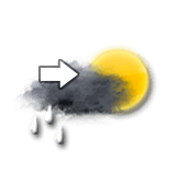
Sunny periods and passing clouds, sometimes heavy.
Showers falling at the end of the afternoon.
Risk of rain
55 %
UV index7High
Freezing level 0°
4050 m
Snow-rain limit
3750 m
Snow expected
0 cm
This evening
18°Feels Like 17°
CalmGusts25 km/h
Very cloudy sky with short clear periods.
A few light showers.
Risk of rain
90 %
UV index1Low
Freezing level 0°
3800 m
Snow-rain limit
3500 m
Snow expected
0 cm
Night
16°Feels Like 15°
CalmGusts10 km/h
Very cloudy sky with short clear periods.
A few light showers.
Risk of rain
75 %
Freezing level 0°
3650 m
Snow-rain limit
3350 m
Snow expected
0 cm
Share
Station Info
Closed
Grindelwald
Snow
N.C.
at the top
(2501m)
0 cm
down
(1034m)
Snowfall
3 months ago : 5 cm 3 months ago : 10 cm 3 months ago : 10 cm